

ANSTO has supported a new study published in Quaternary Science Reviews that dates the dramatic collapse of one of the largest glaciers ever documented in the Himalayas. The findings overturn a long-held assumption about what sustains wet-climate (monsoon dominated) glaciers.
The new study led by the University of Manchester (UK)reconstructs that collapse of a giant Himalayan glacier in unprecedented detail using cosmogenic nuclide measurements at ANSTO. The work provides the first dated glacial chronology for the roughly 1,000-kilometre stretch of the southern Himalayan slopes east of Everest, a region that has long been a blank space on the map of Himalayan glacial history.
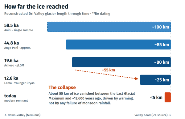
Around 58,500 years ago, a glacier nearly 100 kilometres long filled the Dri Valley in the Dibang region of Arunachal Pradesh in the far eastern Himalayas east of Mount Everest. Its tongue reached down to between 1,300 and 1,500 metres above sea level, lower than many of India’s modern hill stations, and among the lowest glacier termination point documented anywhere in the Himalayan-Tibetan region. Today its largest surviving remnant is less than five kilometres long.
The team led by Shashank Nitundil of the University of Manchester combined satellite mapping, digital elevation models and several months of fieldwork in dense, steep, monsoon-soaked terrain. With logistical support from the Mishmi community, the researchers identified the glacier’s fingerprints in the landscape: U-shaped valleys, cirques, moraines, and bedrock smoothed and plucked by passing ice into the classic roche moutonnée form, rounded on the upstream side and jagged downstream.
Reading time in the rocks
To turn those landforms into dates, the team turned to terrestrial cosmogenic nuclide dating. When a glacier retreats and exposes a rock surface, cosmic rays begin producing rare isotopes such as beryllium-10 (10Be) within the quartz. The longer the surface has been exposed, the more 10Be it contains, making the isotope a natural clock for the deglaciation process
The team collected 63 samples (53 boulders and 10 bedrock surfaces) and shipped them to Australia. At the cosmogenic sample preparation laboratory within the Centre for Accelerator Science (CAS), the samples were crushed, purified and chemically processed down to pure beryllium oxide, including quartz etching by the hot phosphoric acid method developed at ANSTO. The ¹⁰Be was then measured on the SIRIUS accelerator mass spectrometer, which can detect these isotopes at concentrations of just a few parts in a thousand trillion.
ANSTO scientists Dr David Fink and Krista Simon are co-authors on the study, contributing to fieldwork and the laboratory analysis. Lead author of the paper and University of Manchester team was Dr Shashank Nitundil. Support for the cosmogenic dating capability at the Centre is provided through the National Collaborative Research Infrastructure Strategy (NCRIS).
A glacier that died in stages
The ¹⁰Be ages reveal a glacier that did not simply shrink steadily but retreated in distinct steps. At its maximum, before about 58,500 years ago, it stretched close to 100 kilometres. By around 44,800 years ago it had pulled back somewhat, and even at the global Last Glacial Maximum about 19,600 years ago, the coldest phase of the last Ice Age, it still extended roughly 80 kilometres. Then came a sharp decline: by about 12,600 years ago the glacier had collapsed to around 25 kilometres, with high bowl- shaped basins becoming ice-free by roughly 13,000 years ago.
That step-like pattern matters. As the authors note, it points to the potential for abrupt shifts in glacier extent rather than gradual wasting, shifts that can reshape river flow, sediment transport and downstream stability.
Temperature, not rainfall, holds the key
The most striking result challenges a common assumption. The eastern Himalayas are among the wettest places in High Mountain Asia, fed by the Indian Summer Monsoon, and it might be thought that abundant precipitation would protect their glaciers. The Dri Valley record shows otherwise.
Across the last glacial cycle, the glacier expanded and contracted primarily in response to temperature, with precipitation acting only as a secondary modulator. During cold phases, monsoon moisture fell as snow and the glacier grew to enormous size; as temperatures rose, that same moisture fell increasingly as rain rather than snow, cutting off accumulation while accelerating melt.
Crucially, the glacier remained large even through the relatively dry Last Glacial Maximum, demonstrating that it was warming, not a lack of rainfall, that ultimately drove its retreat.
In other words, monsoon-fed glaciers cross a temperature threshold beyond which heavy rainfall offers no protection at all. As lead author Shashank Nitundil put it, these wet Himalayan regions are among the most vulnerable to ice loss.
The findings carry a contemporary warning. As eastern Himalayan glaciers retreat, they leave behind depressions that fill with meltwater to form new lakes, and the eastern Himalayas now host a growing number of them.
When such lakes overtop or breach, the result can be a glacial lake outburst flood capable of devastating valleys downstream, an acute concern in a region carrying some of the highest concentrations of hydropower infrastructure anywhere in the world.
Robust reconstructions of how these glaciers behaved in the past also give climate scientists a benchmark for testing their models. The better a model can reproduce known glacier history, the more confidence it earns for projecting the future.
By filling a major geographic gap in the Himalayan record, the Dri Valley chronology, underpinned by accelerator measurements made in Sydney, adds a valuable new constraint for understanding one of the world’s most climate-sensitive mountain systems.
Thanks to Dr Mitra Safavi Naeini for her contribution to this article.